AutoPylot for Drones
- 4.8
- Rating
- 100.00K
- Installs
- Free
- Price

 Analysis by App-foxy
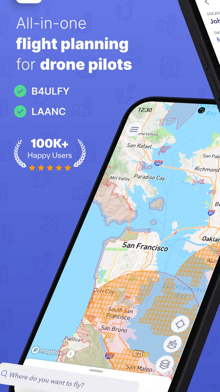
Flying a drone responsibly is rarely just a matter of lifting off and steering. Before the propellers turn, I may need to check airspace, look at the weather, confirm a local flight requirement, prepare a mission, and make sure the aircraft and paperwork are ready. That is where AutoPylot for Drones makes sense: it brings several planning tasks into one productivity app rather than leaving me to jump between unrelated tools.
My first impression is that this is less of a flying controller and more of a preparation companion. Its focus is on airspace information, B4UFLY, LAANC, drone insurance, weather, checklists, and missions. In other words, it aims to reduce the mental load around a flight. The app is free to download, with optional in-app purchases ranging from $3.99 to $39.99 per item, so I can explore its basic workflow before deciding whether the paid elements are worthwhile.
AutoPylot, INC developed the app, which is available for Everyone and supports Android 9 or later. It was released on May 2, 2023, and the current version is 1.21.2. Its reception is strong, with a 4.8 average from around 4.2 thousand ratings and over 100 thousand installs. Those figures do not replace my own judgment, but they do suggest that the app has found an audience among people who want more structure around drone operations.
You May Also Like

 Blood Strike: 2.5 Anniversary
Blood Strike’s Loadouts Turn Every Drop Into a Tactical Gamble
A close look at Blood Strike’s custom loadouts: how fast access to signature weapons reshapes its battle royale rhythm, rewards preparation, and narrows the gap between fights.

 Pandora - Music & Podcasts
Pandora’s Music Is Easy to Start, but Harder to Recover
Pandora’s strength is its low-effort path from a seed to a station. Its weak spot is how much confidence it asks you to place in connection, setup, and quiet recovery.

 8 Ball Pool
 Is Built on Rivalries, Rematches, and Routine
A close look at the rivalries, rematches, shared routines, and unanswered safety questions that turn a quick pool match into a persistent mobile community.

 Samsung Music
’s Quiet Strength Is Playing What You Already Own
Its reach comes less from spectacle than from dependable access to a personal library. That simplicity is both the app’s strongest retention engine and its ceiling.

 AccuWeather: Weather Radar
AccuWeather Review: A Quick, Clear Forecast for Everyday Decisions
For everyday plans, the best forecast is the one you can understand quickly. AccuWeather makes rain timing, radar, and local conditions easy to act on, with a few trade-offs.

 Hill Climb Racing
Why Hill Climb Racing Still Turns Crashes Into One More Run
A tiny car, a bumpy hill and one more upgrade: Hill Climb Racing keeps resurfacing because its simple chaos makes every near-miss feel personal.
More From Our News Desk
View All News


Where connectivity becomes part of the flight plan
The most important thing to understand is that many of the app’s useful moments naturally depend on current information. Airspace status, weather, and LAANC-related planning are not static subjects. When I use AutoPylot before a flight, I treat it as a connected planning tool: I open it where I have a dependable signal, review the relevant information, and avoid assuming that a screen I saw earlier is still current.
This matters especially when I am preparing to fly somewhere unfamiliar. A saved idea for a location is not enough by itself. Conditions can change, restrictions can matter, and a previously comfortable plan may need to be adjusted. AutoPylot’s value comes from putting these checks into the same drone-focused workflow, so I am less likely to forget one simply because it lives in a different app or website.
The B4UFLY and LAANC references are particularly useful for pilots who want a clearer route through preflight responsibilities. Rather than treating authorization and airspace research as an afterthought, I can make them part of the same routine as checking the forecast. That does not mean the app removes my responsibility as the pilot. It gives me a more organized place to begin, while I still need to read the information carefully and make the final safety decision myself.
There is also a practical connectivity trade-off here. An app that deals with live or changing aviation information is most valuable when it can reach current services. I would not plan a remote flight around the assumption that every screen will remain usable without a connection. My safer habit is to complete the important checks before leaving reliable coverage, then treat the app as one part of a broader preparation process rather than as a guarantee that information will always be available in the field.
For that reason, I see AutoPylot as strongest during the preparation window: at home, in the car before departure, or at a location where my phone can still communicate properly. It is less convincing as the only tool I would depend on after arriving somewhere with weak reception. That distinction is easy to miss if I think of it as a simple drone utility instead of a connected planning service.
How I use it before leaving home
My preferred workflow begins with the mission rather than the aircraft. I think about what I want to accomplish, then use the app’s planning features to turn that idea into a sequence of checks. I review the airspace information, look at weather, consider whether LAANC is relevant, and run through a checklist before packing the drone. This order helps because it can reveal a problem while I still have time to change the location or schedule.
A useful habit is to separate “can I fly here?” from “should I fly today?” Airspace and authorization answer one kind of question, while weather and the actual mission answer another. Keeping those decisions distinct prevents a legal possibility from being mistaken for a good operating plan. AutoPylot brings both subjects close together, but I still have to apply judgment rather than simply looking for a green light.
The mission feature also changes how I think about repeat work. If I regularly capture the same kind of footage, a mission-oriented approach can make preparation more consistent. I can use a repeatable sequence instead of relying on memory each time. The real benefit is not a flashy interface; it is the reduction of small omissions, such as forgetting a weather check or failing to consider the airspace before loading the drone into the car.
One non-obvious advantage is that checklists can protect me from being overconfident. Experienced pilots are often the people most likely to rush through familiar tasks. A short checklist creates a pause between “I have done this before” and “I have checked today’s conditions.” I would use it not only for beginners but also for routine flights where familiarity can become a weakness.
Using the app in changing mobile situations
Drone planning often happens in awkward places: standing beside a vehicle, walking toward a launch point, or trying to make a decision while the weather changes. AutoPylot’s mobile format suits those moments better than a desktop-only planning system. I can review the relevant planning areas from the same device I carry to the flight site, without rebuilding the entire process elsewhere.
Still, mobile convenience is not the same as perfect field readiness. A phone screen is small, sunlight can make details harder to read, and switching between planning information and the aircraft’s own controls can interrupt concentration. I would rather complete the detailed review before launching, then use the phone at the site for confirmation and adjustments. That keeps the actual flight from becoming a hurried research session.
A realistic example would be a weekend landscape shoot. Before leaving, I create the mission, check the airspace, review the weather, and consider the authorization path. At the destination, I look again at the conditions and confirm that the location still fits the plan. If the signal is poor, I do not treat that as a minor inconvenience; I regard it as a reason to pause and verify what I can through other reliable means before proceeding.
This is also where the weather section earns its place. Weather is not just a number to glance at once. Wind, visibility, and changing conditions can affect whether the planned shot is sensible, even when the airspace is acceptable. I find the app more useful when I use the forecast as a decision input rather than as a decorative preflight screen.
Insurance information adds another layer to the mobile workflow. It encourages me to think about the flight as an activity with practical consequences, not only as a technical exercise. I would not assume that seeing insurance-related tools inside the app automatically means I am covered. Instead, I would use that area as a prompt to review my own situation and understand what applies to my aircraft, location, and type of work.
What happens when a plan breaks
Good planning apps are tested most clearly when conditions stop cooperating. A weather change, a connectivity problem, an unexpected airspace concern, or a missing authorization can turn a simple outing into a decision point. AutoPylot helps by giving me a central place to revisit the plan, but it cannot make an unsuitable flight suitable. Its role is to make the reason for stopping or changing course easier to identify.
If a check fails, I would avoid repeatedly refreshing the same screen and hoping the issue disappears. My recovery process would be to stop the launch sequence, note which part of the plan is uncertain, and move to a position with better connectivity if that is safe and practical. I would then recheck the relevant information rather than assuming that an earlier result still applies. This is a small but important discipline when using any connected aviation app.
The checklist feature is useful after an interruption too. When a phone call, conversation, or equipment issue breaks my concentration, I can return to a defined sequence instead of trying to remember where I left off. That is a more meaningful benefit than simply having a list on screen. It gives the flight a recovery point and reduces the chance that I skip a step because I feel rushed.
There is a limit, however. AutoPylot should not be treated as a replacement for the aircraft manufacturer’s flight controls, official requirements, or my own direct assessment of the launch area. It organizes planning, but it does not remove the need to inspect the drone, understand its behavior, and follow the rules that apply to the operation. Pilots looking for an all-in-one system that controls every part of the aircraft may find its scope narrower than expected.
I also think about what happens when the app itself is not the best source for a particular question. If I need definitive regulatory guidance or a detailed aircraft-specific procedure, I would go to the appropriate official or manufacturer resource rather than forcing AutoPylot to answer something outside its planning role. That is not a flaw unique to this app; it is a sensible boundary that keeps convenience from becoming overreliance.
Using it without wasting mobile data
Because AutoPylot brings together several information-heavy planning subjects, I would use it deliberately when my connection is limited. I would avoid opening every section repeatedly at the launch site and instead do the broad research earlier, when I have stable service. The aim is not merely to save data; it is to reduce the chance that a slow connection turns a safety check into a rushed guess.
A practical routine is to prepare the mission and checklist first, then review only the information that can change close to departure. Weather deserves a fresh look because it is time-sensitive. Airspace and authorization deserve careful attention because a misunderstanding there can affect whether the flight should happen at all. This prioritization makes the app more manageable on a mobile connection and keeps the most important checks visible in my thinking.
I would also be cautious about assuming that a previously viewed result is current just because it appears familiar. Connected planning tools are useful precisely because they can reflect changing information, which means old confidence can be misleading. If I travel from a strong-signal area to a remote site, I would complete the essential review before leaving and keep my plan conservative if I cannot verify a change later.
The same principle applies to paid features. Since the app is free but offers purchases from $3.99 to $39.99 per item, I would first learn which parts of my workflow I actually use. A frequent commercial pilot may value expanded planning or operational tools more than someone who flies occasionally for recreation. I would not pay simply because a feature sounds comprehensive; I would ask whether it solves a repeated problem in my own preparation.
That approach makes AutoPylot easier to evaluate fairly. The free entry point lowers the risk of trying it, while the purchase range means the total value depends on how deeply I use it. Someone who only wants a quick weather glance may prefer simpler tools. Someone who wants airspace, B4UFLY, LAANC, insurance, checklists, and missions in one drone-centered workflow has a stronger reason to explore what the optional tools add.
Who benefits most from this approach
I would recommend AutoPylot to newer pilots who want a repeatable preflight habit, especially those who feel overwhelmed by the number of separate checks involved in responsible flying. It is also a good fit for recreational pilots who fly in different places and want to organize each outing around a mission instead of improvising at the last minute.
It may be even more useful for pilots who perform recurring work. A consistent checklist and mission process can make preparation easier to hand off mentally from one job to the next. The app does not magically standardize the entire operation, but it can provide a common routine for the planning side, which is where small omissions often happen.
I would be more hesitant to recommend it as the only companion for a pilot who spends most of the time in remote areas with unreliable service. The connectivity angle is central: the app is most comfortable when I can review changing information reliably. In that situation, a pilot may prefer a broader preparation system that includes dependable procedures and official resources outside the app, with AutoPylot serving as an additional layer rather than the sole reference.
It is also not the obvious choice for someone searching only for a flight simulator, video editor, or dedicated aircraft controller. Its strengths are planning and operational organization. If those are not the problems I am trying to solve, the app may feel like extra process instead of useful support.
My final view on AutoPylot for Drones
After using AutoPylot for Drones as a planning companion, I see its main strength in bringing disconnected preflight concerns into one mobile workflow. Airspace, B4UFLY, LAANC, weather, insurance, checklists, and missions make sense together because they all influence the decision to fly and the way I prepare to do it.
Its biggest qualification is equally clear: connectivity shapes the experience. I would use it where I can review current information with confidence, complete the important work before heading into a weak-signal area, and avoid treating the app as a substitute for official guidance or pilot judgment. That is a reasonable trade-off for a tool built around changing flight information.
The free download makes it approachable, the Everyone rating keeps it broadly accessible, and the strong 4.8 average from around 4.2 thousand ratings shows that many users appreciate its direction. I would still judge the optional purchases by my own flying frequency and workflow rather than by the feature list alone.
My recommendation is straightforward: try it if your main problem is organizing drone preparation, not controlling the aircraft itself. Use the checklist to slow down familiar routines, use missions to give repeat flights structure, and treat every connected result as something to review responsibly. For pilots who value a more disciplined preflight process, AutoPylot is a practical addition. For pilots who need a fully offline, aircraft-control-first solution, it is probably better viewed as one useful piece of the kit rather than the whole answer.
FAQs for AutoPylot for Drones
01What is AutoPylot for Drones?
AutoPylot is a drone flight-planning and control application designed to help pilots organize missions, monitor aircraft information, and operate compatible drones from a mobile device. Depending on the supported drone model and app version, it may provide features such as waypoint planning, mapping, telemetry, camera control, automated flight routines, and mission management. Always check the current compatibility list before downloading.
02Which drones and mobile devices are compatible with AutoPylot?
Compatibility can vary significantly by drone model, controller, operating system, and application version. Before installing AutoPylot, review the developer’s official compatibility information and confirm that your drone, remote controller, Android phone, or iPhone is supported. A device may install the app successfully but still lack access to certain flight or camera features because of hardware, firmware, regional, or operating-system limitations.
03Is AutoPylot safe to use for automated drone flights?
AutoPylot can assist with planning and managing automated missions, but it does not remove the pilot’s responsibility for safe operation. Before starting a mission, inspect the drone, verify GPS and battery status, confirm the planned route, and check local aviation regulations. Maintain visual awareness whenever required, keep a way to interrupt the mission, and avoid relying on automation near people, buildings, trees, power lines, or restricted airspace.
04Does AutoPylot require an internet connection or account?
Some functions may work offline after maps, mission data, or other required resources have been downloaded, while features such as map updates, cloud synchronization, account services, support tools, or licensing checks may require an internet connection. Requirements can differ between versions and platforms. It is sensible to sign in, update the app, and prepare mission data before reaching the launch location, where mobile coverage may be unreliable.
05Is AutoPylot free to download, and are there in-app purchases?
The download price and available features depend on the platform, region, and current release. AutoPylot may offer a free installation with selected tools, while advanced flight planning, professional mapping, automation, cloud services, or other capabilities could require a purchase, subscription, or compatible hardware. Check the Google Play Store or Apple App Store listing for the latest pricing, trial conditions, and any recurring charges before confirming installation.
Pros
- Supports automated flight planning for more consistent drone missions.
- Can help reduce pilot workload during repetitive surveying tasks.
- Useful for mapping
- inspection
- and other structured flight operations.
- Provides a more organized workflow than manually controlling every flight step.
- May improve mission repeatability across multiple flights and locations.
Cons
- Compatibility may vary depending on the drone model and controller.
- Automated flights still require careful planning and active supervision.
- Advanced features may take time for beginners to understand.
- Weather
- GPS
- and signal issues can interrupt or affect missions.
- Some features may require paid access or additional compatible hardware.

AutoPylot for Drones
Gallery